In offerta!
Antique Map-MAP-SCOTLAND-SHETLAND ISLANDS-UK-Anonymous-1806
$ 57.27
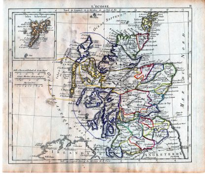
Description This print shows a view on a map of Scotland with the Shetland islands. Made by an anonymous engraver/artist. Medium: engraving on handlaid (verge) paper. Sheet size: 23.5 x 20 cm (9.25 x 7.87 inch). Image size: 21.2 x 18 cm. (8.35 x 7.09 inch). Condition: fair, given age. Brownish edges. Stains from moisture. Folds as published. General age-related toning and/or occasional minor defects from handling. Please study scan carefully. MAP-SCOTLAND-SHETLAND ISLANDS-UK | RBOS-A11-03 BACKGROUND INFORMATION This attractive print was published in the Atlas portatif containing the geographical universe of ancient and modern times, by Eustache Herisson, Paris: Desray, 1806.
Prodotti correlati
- In offerta!
- In offerta!
- In offerta!
- In offerta!